North Cascades National Park is a pristine, mountainous, forested wilderness in northern Washington. The park protects the largest concentration of glaciers – over 300 glaciers as of 2023 – in the lower 48 states. It also houses some impressive mountain peaks… like the Picket Range, which resembles the Swiss Alps. To this day, Thornton Lake in North Cascades is one of my favorite hikes I’ve completed in all of the national parks. Given some of the other incredible hikes I’ve done, this is high praise.
During the winter, hardly anyone visits North Cascades due to heavy snowfall and a severe risk of avalanches. Most visitors see the park from May to September, when Washington’s weather is clearest and most of the winter snow is melted. The best time to visit is from late June through August. Make note of this when you plan a trip to the park.

Despite it’s beauty and close proximity to Seattle, North Cascades is one of the least visited national parks in the country! Before I delve into the meat of this article – the Thornton Lake hike of North Cascades – let me elaborate on this odd statistic.
Plan your trip to North Cascades National Park
Why Does Nobody Visit North Cascades National Park?
Only a few thousand people visit North Cascades every year. In 2021, it received 17,855 visitors, making it the fourth least visited of the national parks. Since the park sits only 2 hours from Seattle and is absolutely beautiful, this may seem strange. Why don’t more people make the trip to the park?

The first reason is simple: weather. Washington is known for highly unpredictable weather, especially in the winter, and especially in the mountains. The unpredictable weather is even worse in North Cascades. As I mentioned, the park is buried in snow throughout much of the year. The highway in the park typically closes from November until April every year, which completely bars people from entering. Most trails in the park aren’t free from snow until late summer. So, weather is definitely a factor.
The second reason is a bit more complicated…
North Cascades vs. Ross Lake
When people refer to “North Cascades National Park,” they are often referring to both the actual national park and the park that bisects it: Ross Lake National Recreation Area. Ross Lake is a beautiful piece of land containing three lakes formed by dams along the Skagit River: Ross Lake, Diablo Lake, and Gorge Lake. State Highway 20 – known as the North Cascades Highway – provides easy access into the recreation area.

Along the North Cascades Highway, there is plenty to do and see. Most of these activities, however, reside entirely in Ross Lake National Recreation Area. Many of the popular hikes that people typically associate with the national park – like Thunder Knob and Ross Dam – never enter the national park. Even the park’s visitor center and entrance sign aren’t technically inside the national park.
The Inaccessible North Cascades
To further complicate things, there are no paved roads that enter North Cascades National Park proper. There is a single gravel road – the Cascade River Road – that crosses the park’s border in its southern unit. Other than that, the only way to reach the park is by completing long, ~10-15 mile day hikes that begin in Ross Lake.

So, the national park’s tiny visitation numbers only include the scarce people who make the effort to reach the park’s border. Those that do – however – are rewarded with a blissful escape into a stunning and perfectly-preserved wilderness.
As an analogy, think about Grand Canyon National Park. Pretend the park’s borders were drawn differently, and that the South Rim – where most visitors set foot – was not part of the park. To enter the park, you would instead have to hike ~5 miles into the canyon. If this was the case, Grand Canyon’s 4 million annual visitors would be reduced drastically. The park would likely see only about 5% of the visitors it sees currently. This is exactly the reason why North Cascades sees few visitors.
Visit Paul in the Parks for more national park stories & travel tips!
Thornton Lake: A Gateway to North Cascades
If it’s your first time visiting the North Cascades area, you might choose to stay close to the highway. Even if you don’t visit the national park proper, you can still see some amazing places. Check out my collaborative guest post published on Full Suitcase – linked below – for a suggested day trip itinerary if you don’t plan to stray far from the road.
North Cascades Day Trip (From Seattle): Itinerary, Map & Tips – Full Suitcase
If you want to go the extra mile(s) to actually step into the park, there are several quality day hikes that let you do so. These hikes cross into North Cascades National Park from adjacent areas like Ross Lake:
- Thornton Lake & Trappers Peak (12 miles, ~4,000 feet elevation gain)
- Sourdough Mountain (10.4 miles, ~5,000 feet elevation gain)
- Maple Pass Loop (7.2 miles, ~2,000 feet elevation gain)
- Cascade Pass to Sahale Glacier (11.8 miles, ~4,000 feet elevation gain)
Here, I’ll be talking about my absolute favorite of these: Thornton Lake. Granted, it’s the only one of these hikes I’ve done so far, but I’ll get back to you once I’ve completed the others…

I completed this hike with one of my best friends – Eli – in July of 2021. We had just completed a successful summit of Mount Adams, so we celebrated the victory with a day trip to North Cascades National Park. There, we visited Diablo Lake and the visitor center, then embarked on this long hike. It was a day well-spent, and – though short – it made me desperately want to return to the park.
Thornton Lake at a Glance
Hiking Thornton Lake in North Cascades National Park is not for the faint-hearted. The trail is long at nearly 11 miles. If you add the Trappers Peak detour, the trail is over 12 miles long with about 4,000 feet of elevation gain. For most people, this takes 5-7 hours to complete, potentially longer if you stop to soak in the views. It’s important to start this hike early in the day so you aren’t on the trail when the sun sets.
The trail ultimately leads you to Thornton Lake, the lowest and largest of the three Thornton Lakes. The path leads right to the shore of the lake, offering the opportunity to go for a swim in the cold, clear water. Trappers Peak towers over the lake, and a detour on the way back from Thornton Lake leads to the summit. The detour adds a little more than a mile and about 1,000 feet of elevation gain to the base hike, but is totally worth the effort.
FYI: Some sources refer to the hike as Thornton Lakes (plural), but it is the same hike as Thornton Lake.
Getting to the Thornton Lake Trailhead
Reaching the North Cascades National Park Complex takes 2 hours by car from Seattle. The directions to the park are as follows:
- From downtown, take I-5 north for 45 miles until reaching WA-530 E
- Continue for west for 45 miles on WA-530 until reaching State Route 20
- Continue on west on State Route 20 (aka the “North Cascades Highway”) for 14 miles, at which point you will reach the complex’s west entrance and its entrance sign

Once you reach the park’s entrance sign, continue along the North Cascades Highway for about 5 miles. On the left, you’ll see a sign directing you to Thornton Lake. Turn onto this gravel road and continue for nearly 4 miles, make a sharp right, then continue for another mile to the trailhead. There will likely be few – if any – cars at the trailhead. Don’t let this deter you!
Note: The road to the trailhead is packed with gravel, often covered with potholes, and relatively narrow. The NPS recommends taking a vehicle with AWD to navigate this road, though it is still doable with a two-wheel drive vehicle. In any case: take your time, don’t rush, and approach turns slowly.
Tips Before Starting the Hike
Before embarking on the Thornton Lake and Trappers Peak hike, make note of the following tips:
- Pack plenty of water, at least 3-4 liters
- Pack trail-friendly snacks, like trail mix, granola bars, packaged meats, and dried fruits
- Bring bear spray, as black bears and grizzly bears both reside in North Cascades
- Start the hike early – no later than noon – to ensure you are back to the trailhead before dark
- Wear sturdy hiking boots or hiking shoes that you are comfortable wearing for several hours
Hiking Thornton Lake & Trappers Peak
Once you park: grab your hiking boots, food & water, and a camera. Don’t forget a pair of trekking poles and/or trail crampons, in case you encounter snow on the trail. Though most of the snow melts from this trail by mid-June, it’s common to still find occasional patches of ice and snow at higher elevations. It’s important to be prepared for the possibility of a slippery trail.
Note: As mentioned earlier, the best time to visit North Cascades National Park is in the summer. Late June through August are the best months to guarantee that snow will be melted from most trails.
A Jaunt Through the Woods
Before reaching the highlights of the Thornton Lake hike, you’ll trek through the forest for several miles. Though this forest isn’t as scenic as the views you’ll find later, there is a peaceful serenity in it. The alpine wilderness around you is pristine and untouched. Birds can commonly be heard and seen flying through the trees. If you’re lucky, you might spot a deer, mountain goat, or even a black bear. It’s unlikely that you will encounter many hikers during this stretch… when Eli and I completed the trail, we didn’t encounter another soul until several hours into the hike.

After a few miles of steady elevation gain through the woods, you will finally reach the national park. A post reading “NAT’L PARK BOUNDARY” will greet you. Remember, up until now you’ve technically been hiking in Ross Lake National Recreation Area. Finally, you’ve reached the national park “proper.”
Breaking Free from the Trees
Now that you’ve entered North Cascades National Park, Thornton Lake is practically around the corner.
Around the 4.5-mile mark, the trail breaks through the trees to offer views of the mountains around you. To the southeast, Big Devil Peak, Snowfield Peak, and Ruby Mountain – glaciated peaks on the other side of the park – rise above the tree line. At this point, you’ll find an intersection in the trail. The intersection offers a choice: descend to Thornton Lake, or climb to Trappers Peak? Both options are a must, but let’s start with Thornton Lake.

Swimming in Thornton Lake
Turning left at the intersection, the trail begins its descent to Thornton Lake. The descent is short – about half a mile – but steep. Watch your step. Before long, you will catch your first view of Thornton Lake. Stop here to soak up the view.
After a descent of nearly 500 feet, you’ll reach the lakeshore. Thornton Lake’s crystal-clear water and rocky shoreline beckon you to go for a swim. It’s time to jump in!
Take off a layer or two of clothing, traverse the lake’s edge, and find a spot to jump in. The water is COLD, but don’t hesitate! At this point, the afternoon sun will likely have warmed you up, so the chilly snowmelt will feel heavenly. Swim and splash around in the lake’s clear blue water as long as you are able, then return to the shore and lay out on a rock to dry beneath the sun.


The Climb to Trappers Peak
After getting your fill of Thornton Lake, it’s time for the climax of the hike: the climb to Trappers Peak. From Thornton Lake, you will climb 1,500 feet over 1.2 miles to reach one of the greatest views in the park. This climb is intense and will test your physical ability… don’t underestimate the ascent.
Start by returning up the descent to Thornton Lake. Once reaching the trail intersection, stay left to continue to Trappers Peak. Quickly, the trail will begin a steep ascent up a rocky ridgeline. The views of mountains to the southeast will return, clear and unobscured by trees. Thornton Lake will reappear below you, emphasizing how quickly you’ve climbed.

The trail turns into a rocky scramble as it climbs to the peak. Be careful here: large drop-offs and occasional patches of snow can make the trail treacherous. Watch your step, and take long breaks as you climb the steep path. Don’t forget to stay hydrated.
Trappers Peak: The Most Impressive View of North Cascades
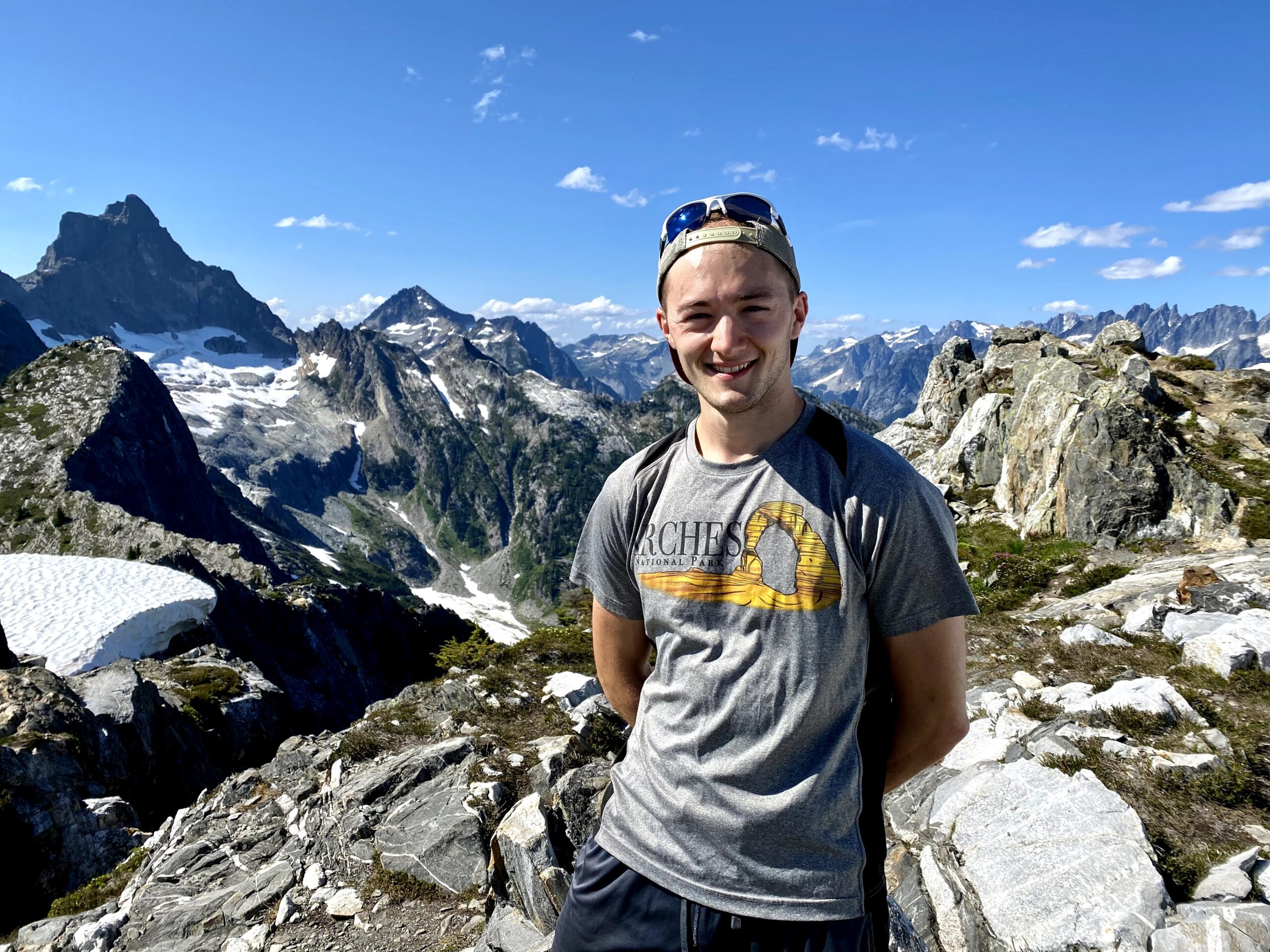
Finally – after 1,000 feet of elevation gain, you’ll step atop the summit of Trappers Peak. Look down at Thornton Lake to see how far you’ve come. More importantly, take a look at the view around you. One of the most impressive panoramas in all of Washington will greet you. The dramatic and rocky Picket Range lies to the north. This range’s stunning jaggedness contributes to the Cascades’ nickname of the “American Alps.” Mount Triumph rises to the northwest, obscuring Mount Baker. Diablo Lake’s blue-green waters make an appearance to the east. Mountains in the national park’s southern unit fill the horizon to the south.

Trappers Peak is a great place to kick back and eat the food that you (hopefully) packed. Enjoy the view and the feel of the sun on your face as you prepare for the return hike.


When Eli and I reached Trappers Peak during our 2021 visit, I fought back tears as I soaked in the view. Something about the mountains around us – jagged, snow-covered, and untouched – struck a chord that few places in this world can. Surprisingly, I discovered I had cell service at the summit. So, I FaceTime-d two of the biggest nature-lovers in my life: my girlfriend Maria and older sister Céline. When they answered, their jaws dropped as I showed them the view around me. Though it would have been much better to have them there with me, I was excited to show them the scenery.


After nearly 45 minutes of celebration, photography, and sightseeing, Eli and I began our return from Trappers Peak. Let’s return to the trail guide…
It’s All Downhill From Here…
From Trappers Peak, you must hike 5.5 miles to return to your car. Thankfully, the return is entirely downhill, making it quick and relatively easy. For most people, it will take about 2-3 hours to get back to the trailhead from Trappers Peak.
During the return, you’ll once again be spending lots of time in trees. Be sure to soak up the sights and sounds as you navigate this dense forest. Take a few moments to pause and let your surroundings overwhelm your senses. You won’t regret it.


North Cascades After Thornton Lake…
Once completing the hike and reaching your car, consider spending some more time in North Cascades! Both the national park and national recreation area offer plenty to do and see for first time visitors. Nearby attractions, like Mount Baker, can help you extend your visit to the area for several days. You can find plenty of campgrounds and lodging options along North Cascades Highway to allow you to stay the night.
Visit my guide page on North Cascades National Park to learn more about the things to do in and around the park. Alternatively, you can check out my guest post on Full Suitcase – mentioned earlier – to find things to do if you only have a day in the park.
Remember: by hiking to Thornton Lake and Trappers Peak, you officially entered into North Cascades National Park. Completing the hike puts you among the elite few people that visit the park every year. While many people visit Diablo Lake and Ross Lake and call it a day, you went the extra miles to visit a place that few people make the effort to see. Plus, you got to see some of the best views in all of Washington… not bad.
Visit New River Gorge – another national park that sees few visitors
— Paul